
1200 King Rd. Changes

Ward 1 Site Address
- 1200 King Rd.
- View the Original 1200 King Road Application page
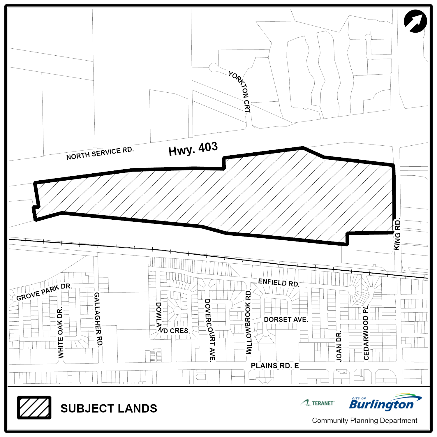
The applicant is proposing to amend the Official Plan and Zoning By-law for the lands located at 1200 King Road to permit a mixed use development consisting of 26 development blocks including: four mixed use development blocks, an entertainment block, three educational blocks, six residential blocks, a park block, two natural heritage system blocks, three blocks associated with Indian Creek, two stormwater management pond blocks, one landscape buffer block, two MTO property line blocks and one future development block.

Applicant
The Alinea Group
Applicant’s Representative:
Bousfields Inc.
Brynne O’Neill
416-947-9744 ext. 237
Proposed Development
- Application to subdivide a 49-hectare parcel of land located north of the CN Rail tracks between King Road and the Aldershot GO Transit Station.
- The subdivision design includes a south service road running east/west, industrial lots of various sizes and blocks for creeks and stormwater management.
- The application is on hold while the applicant completes the outstanding technical studies (including reviews of traffic and environmental impacts). Once these studies are submitted, the application will be circulated for public and technical agency review.
Planner on File
Benjamin Kissner
Community Planning
426 Brant St., Burlington, ON L7R 3Z6
905-335-7777, ext. 7824
benjamin.kissner@burlington.ca
Elyse Meneray
Community Planning
426 Brant St., Burlington, ON L7R 3Z6
905-335-7777, ext. 7824
elyse.meneray@burlington.ca
File Numbers
- Official Plan Amendment: 505-03/26
- Zoning By-law Amendment: 520-04/26
Public Meetings
- Architectural Set Part1-2026-03-16
- Architectural Set Part2-2026-03-16
- Civil Drawings-2026-03-16
- Cover Lette2026-03-16
- Draft OPA with schedules-2026-03-16
- Draft Plan of Subdivision-2026-03-16
- Draft ZBA Schedule-2026-03-16
- Draft ZBA Text-2026-03-16
- Enhanced Functional Servicing and Stormwater Management Report-2026-03-16
- Environmental Impact Assessment-2026-03-16
- Environmental Noise Feasibility Study-2026-03-16
- Fiscal Impact Study-2026-03-16
- Fluvial Geomorphology Assessment-2026-03-16
- Geotechnical Investigation-2026-03-16
- Housing Impact Statement-2026-03-16
- Hydrogeological Assessment-2026-03-16
- Indian Creek Conceptual Channel Design-2026-03-16
- Land Use Compatibility-2026-03-16
- Pedestrian Wind Comfort Assessment-2026-03-16
- Phase 1 ESA-2026-03-16
- Phase 2 ESA-2026-03-16
- Plan of Survey with Feature Limits-2026-03-16
- Plan of Survey-2026-03-16
- Planning Rationale-2026-03-16
- Shadow Studies-2026-03-16
- Slope Stability Assessment-2026-03-16
- Traffic Impact Study-2026-03-16
- Transportation Related Air Pollutants Study-2026-03-16
- Urban Design Brief-2026-03-16
- Wetland Water Balance 2026 03 16
Note: Archaeological Materials have been received for the application, but have not been posted to the development webpage to protect the integrity of the archaeological sites and the artifacts they may contain. These materials can be viewed by making an appointment with Community Planning staff. Please contact the Planners on file if you wish to make an appointment to review these documents.